
Dosiero:2022 Russian invasion of Ukraine.svg

Bildo en pli alta difino (SVG-dosiero, 2 199 × 1 478 rastrumeroj, grandeco de dosiero: 3,72 MB)
| Jen dosiero de la Wikimedia-Komunejo. La priskribo en ties priskriba paĝo estas montrata suben.
|
Rules for editing the map
|
| All edit warring, adding of unsourced information or performing a color change without consensus may result in the user being blocked. All contributions should first be discussed on the talk page. |
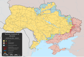
Resumo

|
This file may be updated to reflect new information. If you wish to use a specific version of the file without new updates being mirrored, please upload the required version as a separate file. |
| Priskribo | |||
| Dato | la 24-a de februaro 2022 (first version) | ||
| Fonto |
Propra verko, bazita sur: Russo-Ukrainian conflict (2014-2022).svg by Rr016 & Ukraine adm location map improved.svg by Yakiv Gluck
|
||
| Aŭtoro | Viewsridge | ||
| Ceteraj versioj |
[]
|
||
| SVG genesis | This map is translated using SVG switch elements: all translations are stored in the same file.
|


.gif)

.gif)


_en.png)
_vi.png)
_ru.png)
.svg)
This file is translated using SVG For most Wikipedia projects, you can embed the file normally (without a To translate the text into your language, you can use the SVG Translate tool. Alternatively, you can download the file to your computer, add your translations using whatever software you're familiar with, and re-upload it with the same name. You will find help in Graphics Lab if you're not sure how to do this. |
Permesiloj:
- Vi rajtas:
- kunhavigi – kopii, distribui kaj publikigi la verkon
- aliigi – modifi, adapti, kompletigi, transformi, uzi la tutan verkon aŭ ties partojn, memstare aŭ en aliaj verkoj
- La verko rajtas esti kunhavigata nur:
- atribuite – Vi devas atribui aŭtorecon, liveri ligilon al la permesilo kaj marki ĉu ŝanĝoj estis faritaj. Faru tion en aprobinda maniero, tamen ne sugestante, ke permesinto aprobas vin aŭ vian uzon.
- samkondiĉe – Se vi rekombinas la verkon, transformas ĝin aŭ kreas devenaĵon bazitan sur ĝi, vi rajtas distribui la rezultan verkon nur laŭ la sama aŭ kongrua permesilo kompare kun ĉi tiu.
Dosierhistorio
Alklaku iun daton kaj horon por vidi kiel la dosiero tiam aspektis.
| Dato/Horo | Bildeto | Grandecoj | Uzanto | Komento | |
|---|---|---|---|---|---|
| nun | 04:00, 18 maj. 2024 | | 2 199 × 1 478 (3,72 MB) | Physeters | Fix Bohudukhiv |
| 20:47, 16 maj. 2024 |  | 2 199 × 1 478 (3,72 MB) | Physeters | Updates in Kharkiv Oblast per the ISW | |
| 04:40, 14 maj. 2024 |  | 2 199 × 1 478 (3,72 MB) | Physeters | fix Derhachi | |
| 05:36, 13 maj. 2024 |  | 2 199 × 1 478 (3,72 MB) | Alexiscoutinho | Updated Vovchansk per detailed map | |
| 02:49, 13 maj. 2024 |  | 2 199 × 1 478 (3,72 MB) | Physeters | Updates per the ISW; for future reference, sources (like SuriyakMaps) must first have their reliability vetted on the talk page before they can be used to update the map; at the moment, the only two verified sources are the ISW and the Detailed Map on Wikipedia | |
| 10:34, 12 maj. 2024 |  | 2 199 × 1 478 (3,31 MB) | BlackShadowG | File uploaded using svgtranslate tool (https://svgtranslate.toolforge.org/). Added translation for zh-tw. | |
| 08:46, 12 maj. 2024 |  | 2 199 × 1 478 (3,31 MB) | Miki1234568 | File uploaded using svgtranslate tool (https://svgtranslate.toolforge.org/). Added translation for pl. | |
| 07:54, 12 maj. 2024 |  | 2 199 × 1 478 (3,31 MB) | BlackShadowG | File uploaded using svgtranslate tool (https://svgtranslate.toolforge.org/). Added translation for zh-cn. | |
| 23:02, 11 maj. 2024 |  | 2 199 × 1 478 (3,71 MB) | Mattia332 | As per Renowned Unbiased Open Source "SuriyakMaps", Russian progress in Kharkov | |
| 19:38, 10 maj. 2024 |  | 2 199 × 1 478 (3,71 MB) | Physeters | add date marker |
Dosiera uzado
La jenaj paĝoj ligas al ĉi tiu dosiero:
Suma uzado de la dosiero
La jenaj aliaj vikioj utiligas ĉi tiun dosieron:
- Uzado en af.wikipedia.org
- Uzado en als.wikipedia.org
- Uzado en am.wikipedia.org
- Uzado en ang.wikipedia.org
- Uzado en an.wikipedia.org
- Uzado en ar.wikipedia.org
- Uzado en ary.wikipedia.org
- Uzado en arz.wikipedia.org
- Uzado en ast.wikipedia.org
- Uzado en azb.wikipedia.org
- Uzado en az.wikipedia.org
- Uzado en bat-smg.wikipedia.org
- Uzado en bcl.wikipedia.org
- Uzado en be-tarask.wikipedia.org
- Uzado en be.wikipedia.org
- Uzado en bg.wikipedia.org
- Uzado en bh.wikipedia.org
- Uzado en bn.wikipedia.org
- Uzado en br.wikipedia.org
- Uzado en bs.wikipedia.org
- Uzado en bxr.wikipedia.org
Vidi plian ĝeneralan uzadon de ĉi tiu dosiero.